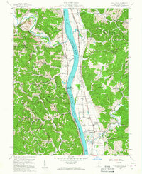
1958 Map of Apple Grove
USGS Topo · Published 1961About this map
The Ohio River forms the central spine of this mid-century survey, dividing Gallia County, Ohio, from Mason County, West Virginia. The river corridor is defined by its industrial and navigational infrastructure, notably the Gallipolis Lock and Dam and a Gaging Sta. Along the eastern bank in West Virginia, the Baltimore and Ohio railroad runs parallel to the water, connecting settlements such as Ben Lomond, Hogsett, and Apple Grove. The landscape transitions from the flat river bottomlands near Mercers Bottom to the deeply dissected ridges of the Clendenin and Hannan districts. Small rural communities are anchored by local institutions like Sunnyside Sch, Elizabeth Chapel, and several family cemeteries, including the Clay Chapel Cem. Evidence of resource extraction appears in the northwest corner with a Strip Mine located near Raccoon Creek.
Find a feature on this map
59 named features on this map. Tap any name to fly to it.
Don’t see what you’re looking for? This feature index may not catch every label — zoom into the map to look around manually.
Map Details
Editions of this 1958 Apple Grove Map
2 editions found
Other maps of this area

1906 · Bidwell
USGS Topo · 1:62,500

1906 · Athalia
USGS Topo · 1:62,500

1906 · Glenwood
USGS Topo · 1:62,500

1908 · Bidwell
USGS Topo · 1:62,500

1908 · Athalia
USGS Topo · 1:62,500

1908 · Glenwood
USGS Topo · 1:62,500

1908 · Point Pleasant
USGS Topo · 1:62,500

1926 · Point Pleasant
USGS Topo · 1:62,500

1929 · Point Pleasant
USGS Topo · 1:62,500

1957 · Beech Hill
USGS Topo · 1:24,000