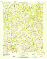
1950 Map of Appleton
USGS Topo · Published 1950About this map
Sugar Creek and the West Fork Shoal Creek carve through the landscape of southern Giles County in this mid-century survey. The settlement at Minor Hill serves as a local hub, situated near the Sam Davis Monument, while other small communities like Appleton and Malone are defined by their proximity to the waterway. The map documents a rural society structured around local gathering points, featuring numerous country schools such as Liberty Hill Sch and Concord Sch, alongside established congregations at Booth Chapel and Mt Zion Ch.
Find a feature on this map
98 named features on this map. Tap any name to fly to it.
Don’t see what you’re looking for? This feature index may not catch every label — zoom into the map to look around manually.
Map Details
Editions of this 1950 Appleton Map
3 editions found
Other maps of this area

1914 · Rogersville
USGS Topo · 1:48,000

1916 · Rogersville
USGS Topo · 1:62,500

1936 · Union Hill
USGS Topo · 1:24,000

1936 · Aspen Hill
USGS Topo · 1:24,000

1936 · Lexington
USGS Topo · 1:24,000

1936 · Lawrenceburg
USGS Topo · 1:24,000

1936 · Pulaski
USGS Topo · 1:24,000

1936 · Bodenham
USGS Topo · 1:24,000

1936 · Appleton
USGS Topo · 1:24,000

1936 · Bonnertown
USGS Topo · 1:24,000