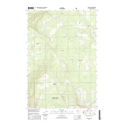
2017 Map of Appleton
USGS Topo · Published 2017About this map
Klickitat Heights and Appleton anchor this mountain landscape in south-central Washington, characterized by a complex network of forest roads and springs. The terrain is defined by its water resources, with numerous named points such as Ellard Spring, Baker Spring, and Snider Spring providing vital sources for the surrounding higher elevations. The map reveals a transition from the structured plots of the Snowden area to the more wilderness-oriented lands of the Gifford Pinchot National Forest in the southwest corner. Local transport is facilitated by roads following the natural contours, including Snowden Rd and Appleton Rd, which connect these small settlements. Features like Snyder Swale and Beaver Pond highlight the varied topography of this Klickitat County region, showing how the landscape supported both forestry and rural habitation in the early 21st century.
Find a feature on this map
59 named features on this map. Tap any name to fly to it.
Don’t see what you’re looking for? This feature index may not catch every label — zoom into the map to look around manually.
Map Details
Editions of this 2017 Appleton Map
This is the sole edition of this map. No revisions or reprints were ever made.
Other maps of this area

1934 · The Dalles
USGS Topo · 1:125,000

1953 · The Dalles
USGS Topo · 1:250,000

1956 · The Dalles
USGS Topo · 1:250,000

1957 · The Dalles
USGS Topo · 1:250,000

1957 · Klickitat
USGS Topo · 1:62,500

1957 · The Dalles
USGS Topo · 1:62,500

1957 · White Salmon
USGS Topo · 1:62,500

1957 · Husum
USGS Topo · 1:62,500

1974 · The Dalles North
USGS Topo · 1:24,000
1975 · Lyle
USGS Topo · 1:24,000