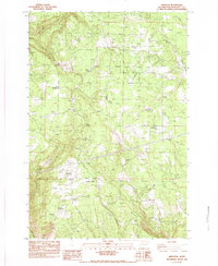
1983 Map of Appleton
USGS Topo · Published 1983About this map
The settlement of Appleton and the high terrain of Klickitat Heights characterize this 1983 provisional survey of Klickitat County. The landscape is defined by its water resources and natural springs, including the notable Beaver Pond and numerous named water sources like Baker Spring, Ellard Spring, and McCowen Spring. These features suggest a rural economy dependent on local hydrology and land use patterns typical of the region's mid-to-late 20th-century development.
Find a feature on this map
24 named features on this map. Tap any name to fly to it.
Don’t see what you’re looking for? This feature index may not catch every label — zoom into the map to look around manually.
Map Details
Editions of this 1983 Appleton Map
This is the sole edition of this map. No revisions or reprints were ever made.
Other maps of this area

1934 · The Dalles
USGS Topo · 1:125,000

1953 · The Dalles
USGS Topo · 1:250,000

1956 · The Dalles
USGS Topo · 1:250,000

1957 · The Dalles
USGS Topo · 1:250,000

1957 · Klickitat
USGS Topo · 1:62,500

1957 · The Dalles
USGS Topo · 1:62,500

1957 · White Salmon
USGS Topo · 1:62,500

1957 · Husum
USGS Topo · 1:62,500

1974 · The Dalles North
USGS Topo · 1:24,000
1975 · Lyle
USGS Topo · 1:24,000