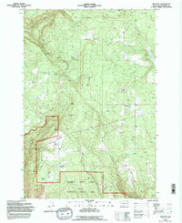
1994 Map of Appleton
USGS Topo · Published 1995About this map
The settlement of Appleton and the high plateaus above the Columbia River Gorge National Scenic Area define this landscape during the mid-1990s. This survey illustrates a rural transition zone where the eastern edge of the Gifford Pinchot National Forest meets the scattered agricultural holdings and timberlands of western Klickitat County. The area is characterized by a high density of water sources named for early families and settlers, including McGowen Spring, Ellard Spring, and Conklin Spring.
Find a feature on this map
34 named features on this map. Tap any name to fly to it.
Don’t see what you’re looking for? This feature index may not catch every label — zoom into the map to look around manually.
Map Details
Editions of this 1994 Appleton Map
This is the sole edition of this map. No revisions or reprints were ever made.
Other maps of this area

1934 · The Dalles
USGS Topo · 1:125,000

1953 · The Dalles
USGS Topo · 1:250,000

1956 · The Dalles
USGS Topo · 1:250,000

1957 · The Dalles
USGS Topo · 1:250,000

1957 · Klickitat
USGS Topo · 1:62,500

1957 · The Dalles
USGS Topo · 1:62,500

1957 · White Salmon
USGS Topo · 1:62,500

1957 · Husum
USGS Topo · 1:62,500

1974 · The Dalles North
USGS Topo · 1:24,000
1975 · Lyle
USGS Topo · 1:24,000