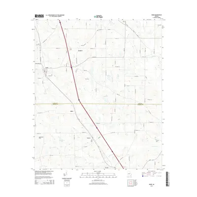
2014 Map of Arabi
USGS Topo · Published 2014About this map
Arabi serves as the primary hub of this South Georgia landscape, where agricultural fields and timber tracts are divided by the straight paths of major transit corridors. The Interstate 75 and Us 41 routes run parallel through the heart of the region, connecting a series of smaller settlements including Sibley, Dakota, and Worth. These communities are often marked by rural burial grounds such as Dakota Cem and Arabi Antioch Cem, providing essential points of reference for genealogists. The terrain is defined by the drainage systems of Lime Cr and the W Fork Deep Cr, which flow toward the Crisp-Turner County line. Notable water features like Youngblood Lake and Haw Pond are interspersed among the family-named roads and rural crossings, illustrating the enduring spatial organization of this farming district.
Find a feature on this map
78 named features on this map. Tap any name to fly to it.
Don’t see what you’re looking for? This feature index may not catch every label — zoom into the map to look around manually.
Map Details
Editions of this 2014 Arabi Map
This is the sole edition of this map. No revisions or reprints were ever made.
Other maps of this area

1953 · Waycross
USGS Topo · 1:250,000

1956 · Sylvester
USGS Topo · 1:62,500

1958 · Waycross
USGS Topo · 1:250,000

1972 · Cuffietown
USGS Topo · 1:24,000

1973 · Ashburn
USGS Topo · 1:24,000

1973 · Bethel
USGS Topo · 1:24,000
1974 · Pitts
USGS Topo · 1:24,000

1974 · Amboy
USGS Topo · 1:24,000
1974 · Cordele
USGS Topo · 1:24,000
1977 · Arabi
USGS Topo · 1:24,000