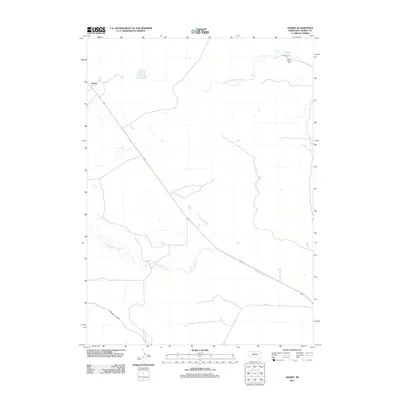
2011 Map of Arabia
USGS Topo · Published 2011About this map
Arabia sits at the northern end of this Nebraska landscape, where the Sandhills terrain meets a network of managed water and small drainages. The primary artery of travel is the diagonal route of 20, which cuts across the territory toward the southeast. Water management is a central theme of the geography, evidenced by the Ainsworth Canal in the southwest and the O'Kief Reservoir and O'Kief Dam in the northeast. These features, along with Evergreen Creek and the South Fork Fairfield Creek, define the drainage patterns of this sparsely settled portion of Cherry County. The presence of Lake St in the lower portion of the map suggests local movement through an otherwise open expanse of cattle country and prairie.
Find a feature on this map
8 named features on this map. Tap any name to fly to it.
Don’t see what you’re looking for? This feature index may not catch every label — zoom into the map to look around manually.
Map Details
Editions of this 2011 Arabia Map
This is the sole edition of this map. No revisions or reprints were ever made.
Other maps of this area

1950 · Norden
USGS Topo · 1:62,500

1950 · Sparks
USGS Topo · 1:62,500

1950 · Wood Lake
USGS Topo · 1:62,500

1950 · Arabia
USGS Topo · 1:62,500

1952 · Norden
USGS Topo · 1:62,500

1957 · Valentine
USGS Topo · 1:250,000

1959 · Valentine
USGS Topo · 1:250,000
1983 · Muleshoe Creek
USGS Topo · 1:24,000
1983 · Thatcher
USGS Topo · 1:24,000
1983 · Sparks SE
USGS Topo · 1:24,000