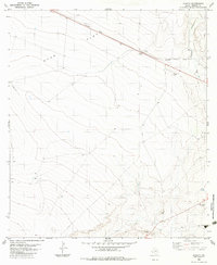
1983 Map of Aragon
USGS Topo · Published 1983About this map
Ryan Flat dominates this high-desert landscape in Presidio County, Texas, during the mid-1970s and early 1980s. The terrain is defined by the steady transit of the Southern Pacific railroad, which cuts diagonally across the arid plains. At the small railroad siding of Aragon, the map records a bench mark and a cluster of structures that served this remote transit point. The geography here is sparse but functional, characterized by essential water sources like Well and Tank sites that sustained ranching or rail operations. To the northeast, the topography becomes more complex as the land drops into Big Trestle Draw, where a railroad trestle crosses the drainage. Evidence of local utility and transport is seen in a lone Gravel Pit and a remote Landing Strip, illustrating how people and materials moved through this expansive West Texas corridor.
Find a feature on this map
8 named features on this map. Tap any name to fly to it.
Don’t see what you’re looking for? This feature index may not catch every label — zoom into the map to look around manually.
Map Details
Editions of this 1983 Aragon Map
This is the sole edition of this map. No revisions or reprints were ever made.
Other maps of this area

1895 · Marfa
USGS Topo · 1:125,000

1959 · Marfa
USGS Topo · 1:250,000

1965 · Marfa
USGS Topo · 1:250,000
1983 · Ryan
USGS Topo · 1:24,000
1983 · Smith Hills
USGS Topo · 1:24,000
1983 · San Esteban Lake
USGS Topo · 1:24,000
1983 · Marfa
USGS Topo · 1:24,000
1983 · Burro Draw
USGS Topo · 1:24,000
1983 · Oak Creek
USGS Topo · 1:24,000
1983 · Oak Hills North
USGS Topo · 1:24,000