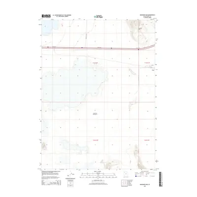
2014 Map of Aragonite NW
USGS Topo · Published 2014About this map
The vast expanse of the Great Salt Lake Desert dominates this Tooele County landscape, where the salt flats meet the rising elevations of the Grayback Hills. The small settlement of Clive is situated on the eastern edge of the quadrangle, serving as a focal point for a specialized road network including Clive Rd and Clive Way. This region is defined by its industrial and transit infrastructure, including the Clive-Complex Rd, which supports operations in this remote desert environment. Transportation is anchored by the Frontage Rd corridor, while Grayback Hills Dr provides access into the higher terrain. The map captures a moment in the modern evolution of the West Desert, documenting the specific intersections and property boundaries within the T1S and T2S townships.
Find a feature on this map
12 named features on this map. Tap any name to fly to it.
Don’t see what you’re looking for? This feature index may not catch every label — zoom into the map to look around manually.
Map Details
Editions of this 2014 Aragonite NW Map
This is the sole edition of this map. No revisions or reprints were ever made.
Other maps of this area

1953 · Tooele
USGS Topo · 1:250,000

1955 · Tooele
USGS Topo · 1:250,000

1973 · Ripple Valley
USGS Topo · 1:24,000

1973 · Knolls
USGS Topo · 1:24,000

1973 · Aragonite NW
USGS Topo · 1:24,000

1973 · Knolls SE
USGS Topo · 1:24,000

1973 · Grayback Hills
USGS Topo · 1:24,000

1973 · Aragonite SE
USGS Topo · 1:24,000

1973 · Aragonite SW
USGS Topo · 1:24,000
1973 · Aragonite
USGS Topo · 1:24,000