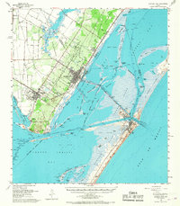
1954 Map of Aransas Pass
USGS Topo · Published 1967About this map
Live Oak Peninsula and the surrounding coastal waters define this mid-century look at the Texas shoreline near the junction of San Patricio, Aransas, and Nueces counties. The landscape is a network of industrial progress and natural barriers, where the Southern Pacific railroad and the Intracoastal Waterway facilitate commerce across Redfish Bay. Early petrochemical development is evident at the refinery and numerous oil tanks near Port Ingleside, while the town of Aransas Pass serves as a central hub for the region.
Find a feature on this map
97 named features on this map. Tap any name to fly to it.
Don’t see what you’re looking for? This feature index may not catch every label — zoom into the map to look around manually.
Map Details
Editions of this 1954 Aransas Pass Map
2 editions found

Other maps of this area

1925 · Aransas Pass
USGS Topo · 1:62,500

1925 · Oso Creek
USGS Topo · 1:62,500

1925 · Corpus Christi
USGS Topo · 1:62,500

1950 · Corpus Christi
USGS Topo · 1:250,000

1951 · Portland
USGS Topo · 1:24,000

1951 · Corpus Christi
USGS Topo · 1:62,500

1951 · Crane Islands NW
USGS Topo · 1:24,000

1951 · Oso Creek NE
USGS Topo · 1:24,000

1951 · Allyns Bight
USGS Topo · 1:24,000

1951 · Oso Creek
USGS Topo · 1:62,500