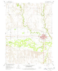
1958 Map of Arapahoe
USGS Topo · Published 1977About this map
Republican River meanders through the heart of this Furnas County landscape, defining the agricultural and transit corridor of Arapahoe. The town is a concentrated hub of activity, featuring the Chicago Burlington and Quincy railroad line running parallel to the river valley. The map documents a highly managed water system essential for the region's farming, marked by several siphons and the Cambridge Canal which skirts the northern bluffs above the floodplains of Muddy Creek and Elk Creek.
Find a feature on this map
21 named features on this map. Tap any name to fly to it.
Don’t see what you’re looking for? This feature index may not catch every label — zoom into the map to look around manually.
Map Details
Editions of this 1958 Arapahoe Map
2 editions found
Other maps of this area

1896 · Arapahoe
USGS Topo · 1:125,000

1898 · Arapahoe
USGS Topo · 1:125,000

1954 · McCook
USGS Topo · 1:250,000

1955 · Grand Island
USGS Topo · 1:250,000

1957 · McCook
USGS Topo · 1:250,000

1957 · Grand Island
USGS Topo · 1:250,000

1958 · McCook
USGS Topo · 1:250,000

1958 · Grand Island
USGS Topo · 1:250,000

1958 · Edison
USGS Topo · 1:24,000
1958 · Arapahoe
USGS Topo · 1:24,000