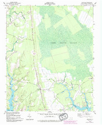
1950 Map of Arapahoe
USGS Topo · Published 1993About this map
Arapahoe sits at the heart of this coastal North Carolina landscape, where the flat coastal plain gives way to the vast Light Ground Pocosin to the east. Surveyed in the late 1940s, the map reveals a rural economy shaped by its proximity to the Neuse River and a dense network of tidal inlets and creeks. Community life is anchored by local landmarks such as St Matthews Ch, St Stephens Ch, and Holts Chapel. The topography is defined by the unique hydrology of the region, including named drainage features like Groovy Gut, Wheeler Gut, and Purifoy Gut. Along the southern shoreline, the development of Minnesott Beach contrasts with the interior wetlands and the winding course of Dawson Creek, while evidence of earlier land use survives in features like the Mill Dam on Mill Creek.
Find a feature on this map
28 named features on this map. Tap any name to fly to it.
Don’t see what you’re looking for? This feature index may not catch every label — zoom into the map to look around manually.
Map Details
Editions of this 1950 Arapahoe Map
2 editions found
Other maps of this area

1948 · Oriental
USGS Topo · 1:24,000

1949 · Havelock
USGS Topo · 1:24,000

1949 · Merrimon
USGS Topo · 1:24,000

1949 · Cherry Point
USGS Topo · 1:24,000

1950 · Vandemere
USGS Topo · 1:24,000

1950 · Upper Broad Creek
USGS Topo · 1:24,000

1950 · Arapahoe
USGS Topo · 1:24,000

1951 · Arapahoe
USGS Topo · 1:24,000
1951 · Merrimon
USGS Topo · 1:24,000
1951 · Cherry Point
USGS Topo · 1:24,000