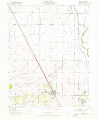
1952 Map of Arbuckle
USGS Topo · Published 1973About this map
Arbuckle serves as the primary hub of this Sacramento Valley landscape, situated along the critical corridor of the Southern Pacific railroad. The 1952 topography reveals an intricate water management system essential for the region's agriculture, defined by the vast Colusa Basin and the Colusa Trough. These lowlands contrast with the western drainages of Cortina Creek, Salt Creek, and Sand Creek that descend toward the valley floor. Educational and civic life is centered at Pierce Union High School in Arbuckle and the neighboring community of College City. To the north, the presence of the Colusa Nat Wildlife Refuge and aviation landmarks like the Radio Range Station and a local Landing Field near Genevra illustrate the varied land use of the mid-century era, from conservation to early modern transportation infrastructure.
Find a feature on this map
34 named features on this map. Tap any name to fly to it.
Don’t see what you’re looking for? This feature index may not catch every label — zoom into the map to look around manually.
Map Details
Editions of this 1952 Arbuckle Map
3 editions found
Other maps of this area

1888 · Marysville
USGS Topo · 1:125,000

1891 · Marysville
USGS Topo · 1:125,000

1894 · Marysville
USGS Topo · 1:125,000

1895 · Marysville
USGS Topo · 1:125,000

1905 · Harrington
USGS Topo · 1:24,000

1907 · Dunnigan
USGS Topo · 1:62,500

1907 · Colusa
USGS Topo · 1:62,500

1911 · Grimes
USGS Topo · 1:31,680

1912 · Meridian
USGS Topo · 1:31,680

1916 · Harrington
USGS Topo · 1:31,680