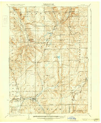
1925 Map of Arcade
USGS Topo · Published 1931About this map
Cattaraugus Creek and its many tributaries carve through the western New York uplands in this mid-1920s survey, anchoring a landscape defined by small dairying communities and decentralized rural schools. The village of Arcade serves as a critical junction where the Pennsylvania and Arcade and Attica railroads meet, facilitating the movement of goods from the surrounding townships. The map records a dense network of local education, including School No 11 and Klem School, alongside numerous crossroads settlements such as Strykersville and Punkshers Corners. Local industry and agriculture are further evidenced by features like Angel Falls and the broad Gallagher Swamp, while family-named landmarks like Rice Corners and Finks Corners provide significant detail for genealogical research. The varied terrain includes elevations like Crow Hill and Vermont Hill, illustrating the transition from open valley floors to high-elevation farmsteads.
Find a feature on this map
94 named features on this map. Tap any name to fly to it.
Don’t see what you’re looking for? This feature index may not catch every label — zoom into the map to look around manually.
Map Details
Editions of this 1925 Arcade Map
4 editions found
Other maps of this area

1904 · Batavia
USGS Topo · 1:62,500

1905 · Attica
USGS Topo · 1:62,500

1905 · Portage
USGS Topo · 1:62,500

1905 · Depew
USGS Topo · 1:62,500

1906 · Angelica
USGS Topo · 1:62,500

1923 · Arcade
USGS Topo · 1:62,500

1924 · Ellicottville
USGS Topo · 1:62,500

1924 · Franklinville
USGS Topo · 1:62,500

1925 · Springville
USGS Topo · 1:62,500

1925 · Arcade
USGS Topo · 1:62,500