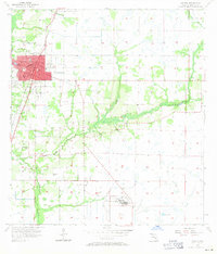
1957 Map of Arcadia
USGS Topo · Published 1971About this map
Arcadia serves as the central hub of this mid-century survey, revealing a landscape defined by the convergence of major rail lines and slow-moving waterways. The city layout is clearly marked by the Courthouse and DeSoto Park, while the surrounding terrain is a network of drainage and wetlands, including Joshua Creek and the southern Deep Lake. The intersection of the Atlantic Coast Line and the Seaboard Air Line railroads underscores the importance of transportation and transit in the Florida interior during the 1950s.
Find a feature on this map
18 named features on this map. Tap any name to fly to it.
Don’t see what you’re looking for? This feature index may not catch every label — zoom into the map to look around manually.
Map Details
Editions of this 1957 Arcadia Map
4 editions found
Other maps of this area

1956 · Gardner
USGS Topo · 1:24,000

1956 · Arcadia SE
USGS Topo · 1:24,000

1956 · Limestone
USGS Topo · 1:24,000

1956 · Ft. Ogden
USGS Topo · 1:24,000

1956 · Nocatee
USGS Topo · 1:24,000

1956 · Crewsville SW
USGS Topo · 1:24,000

1956 · Long Island Marsh SW
USGS Topo · 1:24,000

1956 · Fort Pierce
USGS Topo · 1:250,000

1957 · Long Island Marsh NW
USGS Topo · 1:24,000

1957 · Arcadia
USGS Topo · 1:24,000