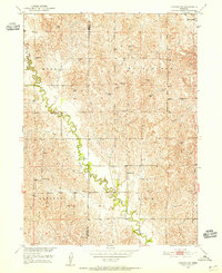
1951 Map of Arcadia SW
USGS Topo · Published 1955About this map
The rolling hills of central Nebraska are defined here by the winding course of Clear Creek as it carves through the borders of Custer and Sherman Counties. This early 1950s survey reveals a landscape organized into the civil townships of Myrtle, Washington, Algernon, and Elm. The density of rural infrastructure speaks to a time of vibrant agricultural life, with a high concentration of country schools positioned for local farm families. Educational landmarks such as Deem Sch and Banner Sch appear along the creek valley, while the Lone Elm Cem and neighboring Lone Elm Sch serve as focal points for the upland community. The terrain is marked by numerous windmills, signaling the vital role of groundwater in sustaining the remote homesteads of this Missouri River Basin development area.
Find a feature on this map
15 named features on this map. Tap any name to fly to it.
Don’t see what you’re looking for? This feature index may not catch every label — zoom into the map to look around manually.
Map Details
Editions of this 1951 Arcadia SW Map
3 editions found
Other maps of this area

1951 · Ansley NE
USGS Topo · 1:24,000

1951 · Arcadia SE
USGS Topo · 1:24,000

1951 · Litchfield NE
USGS Topo · 1:24,000

1951 · Arcadia West
USGS Topo · 1:24,000

1951 · Arcadia East
USGS Topo · 1:24,000

1951 · Mason City
USGS Topo · 1:24,000

1951 · Ansley SE
USGS Topo · 1:24,000

1951 · Arcadia SW
USGS Topo · 1:24,000

1951 · Litchfield
USGS Topo · 1:24,000

1955 · Broken Bow
USGS Topo · 1:250,000