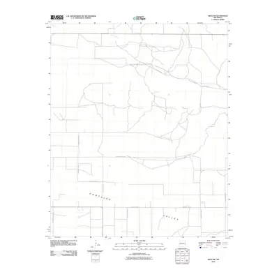
2010 Map of Arch NW
USGS Topo · Published 2010About this map
The Portales Valley defines the topography of this corner of Roosevelt County, where the landscape is organized by an extensive grid of section-line roads. This survey, compiled from imagery taken between 2005 and 2009, illustrates the systematic rural development of the Llano Estacado. The road network, including primary corridors such as Blackwater Rd and S Roosevelt Road 8, reflects the agricultural subdivision of the land. Smaller thoroughfares like S Roosevelt Road S and S Roosevelt Road L provide access to interior parcels, showing how modern transportation routes have been laid over the ancient valley floor. This geometric layout is characteristic of the High Plains, where the absence of major surface water features directed human settlement into a rigorous survey pattern focused on terrestrial accessibility.
Find a feature on this map
12 named features on this map. Tap any name to fly to it.
Don’t see what you’re looking for? This feature index may not catch every label — zoom into the map to look around manually.
Map Details
Editions of this 2010 Arch NW Map
This is the sole edition of this map. No revisions or reprints were ever made.
Other maps of this area

1954 · Clovis
USGS Topo · 1:250,000

1957 · Portair
USGS Topo · 1:62,500

1957 · Clovis
USGS Topo · 1:62,500

1957 · Arch
USGS Topo · 1:62,500

1957 · Portales
USGS Topo · 1:62,500

1958 · Clovis
USGS Topo · 1:250,000

1985 · Midway
USGS Topo · 1:24,000
1985 · Portales SE
USGS Topo · 1:24,000

1985 · Pleasure Lake
USGS Topo · 1:24,000
1985 · Arch
USGS Topo · 1:24,000