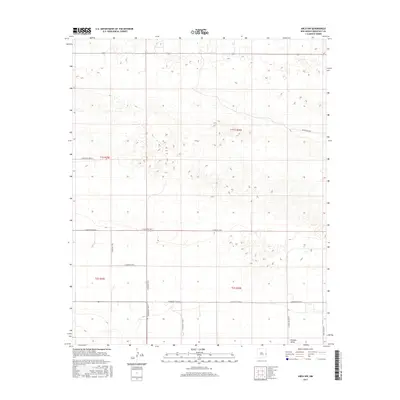
2017 Map of Arch NW
USGS Topo · Published 2017About this map
Portales Valley defines the southern reach of this agricultural landscape in Roosevelt County, where the high plains of eastern New Mexico are organized by a rigid grid of rural roads. This section of the Llano Estacado reveals a pattern of land use typical of the early 21st century, with long, straight thoroughfares such as Blackwater Rd and S Roosevelt Rd 6 segmenting the territory into large township blocks. The terrain is marked by numerous small, seasonally dry depressions and gentle undulations characteristic of the area's wind-swept geology. While no major towns occupy this specific quadrangle, the systematic numbering of routes like S Roosevelt Rd K and S Roosevelt Road J reflects the enduring importance of the Public Land Survey System in managing this expansive ranching and farming corridor.
Find a feature on this map
16 named features on this map. Tap any name to fly to it.
Don’t see what you’re looking for? This feature index may not catch every label — zoom into the map to look around manually.
Map Details
Editions of this 2017 Arch NW Map
This is the sole edition of this map. No revisions or reprints were ever made.
Other maps of this area

1954 · Clovis
USGS Topo · 1:250,000

1957 · Portair
USGS Topo · 1:62,500

1957 · Clovis
USGS Topo · 1:62,500

1957 · Arch
USGS Topo · 1:62,500

1957 · Portales
USGS Topo · 1:62,500

1958 · Clovis
USGS Topo · 1:250,000

1985 · Midway
USGS Topo · 1:24,000
1985 · Portales SE
USGS Topo · 1:24,000

1985 · Pleasure Lake
USGS Topo · 1:24,000
1985 · Arch
USGS Topo · 1:24,000