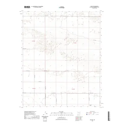
2020 Map of Arch NW
USGS Topo · Published 2020About this map
Portales Valley defines the southern landscape of this Roosevelt County region, where the flat plains of the Llano Estacado meet the distinct depression of an ancient drainage system. The terrain is structured by an exacting grid of section lines and range boundaries, including t1s r35e and t2s r36e, which organize the agricultural and ranching layout of the area. Transportation is strictly utilitarian, following the cardinal directions via a network of secondary routes such as S Roosevelt Road 6 and S Roosevelt Road 8. The presence of Blackwater Rd in the northeast corner hints at the proximity to significant paleo-Indian archaeological sites found in this part of New Mexico. This survey captures a rural landscape where the natural geography of the valley remains the primary landmark amidst the modern land-division system.
Find a feature on this map
16 named features on this map. Tap any name to fly to it.
Don’t see what you’re looking for? This feature index may not catch every label — zoom into the map to look around manually.
Map Details
Editions of this 2020 Arch NW Map
This is the sole edition of this map. No revisions or reprints were ever made.
Other maps of this area

1954 · Clovis
USGS Topo · 1:250,000

1957 · Portair
USGS Topo · 1:62,500

1957 · Clovis
USGS Topo · 1:62,500

1957 · Arch
USGS Topo · 1:62,500

1957 · Portales
USGS Topo · 1:62,500

1958 · Clovis
USGS Topo · 1:250,000

1985 · Midway
USGS Topo · 1:24,000
1985 · Portales SE
USGS Topo · 1:24,000

1985 · Pleasure Lake
USGS Topo · 1:24,000
1985 · Arch
USGS Topo · 1:24,000