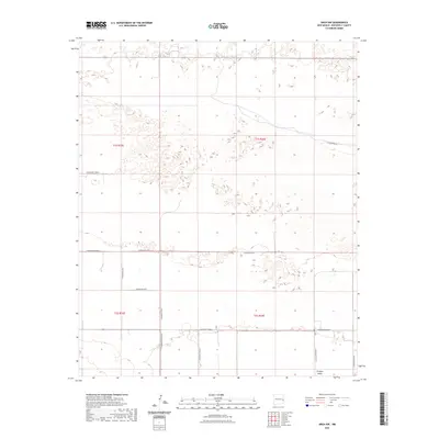
2023 Map of Arch NW
USGS Topo · Published 2023About this map
The Portales Valley defines the southern portion of this high plains landscape, a region characterized by its broad, flat depressions and a network of section-line roads that underscore the deep-seated agricultural heritage of Roosevelt County. The systematic layout of the Public Land Survey System is visible through the grid of thoroughfares like S Roosevelt Road 4 and S Roosevelt Road 6, which have long served as the lifelines for local homesteads and ranching operations. Along the northeastern edge, Blackwater Rd cuts a diagonal path across the landscape, following a different logic than the rigid cardinal grid. This 2023 survey by the U.S. Geological Survey captures the modern state of these rural corridors, such as S Roosevelt Road 8 and S Roosevelt Road J, providing a clear look at the enduring geometry of New Mexico's eastern plains.
Find a feature on this map
16 named features on this map. Tap any name to fly to it.
Don’t see what you’re looking for? This feature index may not catch every label — zoom into the map to look around manually.
Map Details
Editions of this 2023 Arch NW Map
This is the sole edition of this map. No revisions or reprints were ever made.
Other maps of this area

1954 · Clovis
USGS Topo · 1:250,000

1957 · Portair
USGS Topo · 1:62,500

1957 · Clovis
USGS Topo · 1:62,500

1957 · Arch
USGS Topo · 1:62,500

1957 · Portales
USGS Topo · 1:62,500

1958 · Clovis
USGS Topo · 1:250,000

1985 · Midway
USGS Topo · 1:24,000
1985 · Portales SE
USGS Topo · 1:24,000

1985 · Pleasure Lake
USGS Topo · 1:24,000
1985 · Arch
USGS Topo · 1:24,000