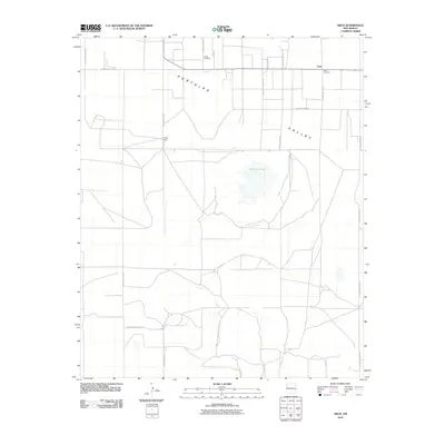
2010 Map of Arch
USGS Topo · Published 2010About this map
Arch sits at the northeastern corner of this 2010 survey, serving as a primary settlement point within the broad Portales Valley of Roosevelt County. The landscape is defined by its rectilinear grid of agricultural roads, including S Roosevelt Road G and S Roosevelt Road 10, which connect various rural holdings. For genealogists, the map identifies two significant burial grounds: Eiland Cemetery, located north of the valley's main east-west corridor, and Arch Cemetery, situated just east of the village. The terrain is relatively flat, punctuated by the seasonal waters of Little Salt Lake, which dominates the central portion of the quadrangle. Other notable landmarks include the Phillips Ranch, providing a specific point of reference for family history researchers looking to locate 21st-century property boundaries and rural footprints.
Find a feature on this map
17 named features on this map. Tap any name to fly to it.
Don’t see what you’re looking for? This feature index may not catch every label — zoom into the map to look around manually.
Map Details
Editions of this 2010 Arch Map
This is the sole edition of this map. No revisions or reprints were ever made.
Other maps of this area

1954 · Clovis
USGS Topo · 1:250,000

1954 · Brownfield
USGS Topo · 1:250,000

1957 · Arch
USGS Topo · 1:62,500

1957 · Portales
USGS Topo · 1:62,500

1958 · Brownfield
USGS Topo · 1:250,000

1958 · Clovis
USGS Topo · 1:250,000

1962 · Brownfield
USGS Topo · 1:250,000

1970 · Causey East
USGS Topo · 1:24,000
1972 · Causey West
USGS Topo · 1:24,000

1972 · Dora
USGS Topo · 1:24,000