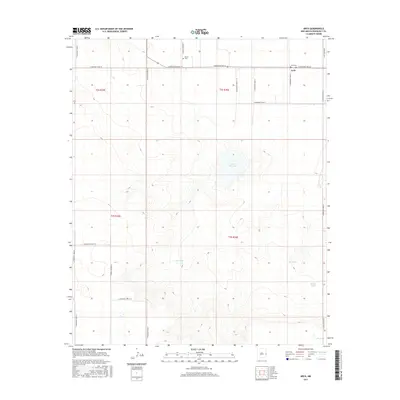
2017 Map of Arch
USGS Topo · Published 2017About this map
Arch sits at the northeastern corner of this Roosevelt County quadrangle, a small settlement defined by a grid of rural routes. The landscape is marked by a series of named water features, including Little Salt Lake and several stock tanks such as West Tank, East Tank, and Middle Tank, which reflect the ranching and agricultural nature of this High Plains region. For genealogists and local historians, the presence of the Arch Cem and Elland Cem provides vital points of reference for tracing the early community families who settled this part of New Mexico. The map reveals a strictly organized section-line road system, with thoroughfares like S Roosevelt Road 10 and S Roosevelt Road K providing the primary connectivity across the open terrain.
Find a feature on this map
24 named features on this map. Tap any name to fly to it.
Don’t see what you’re looking for? This feature index may not catch every label — zoom into the map to look around manually.
Map Details
Editions of this 2017 Arch Map
This is the sole edition of this map. No revisions or reprints were ever made.
Other maps of this area

1954 · Clovis
USGS Topo · 1:250,000

1954 · Brownfield
USGS Topo · 1:250,000

1957 · Arch
USGS Topo · 1:62,500

1957 · Portales
USGS Topo · 1:62,500

1958 · Brownfield
USGS Topo · 1:250,000

1958 · Clovis
USGS Topo · 1:250,000

1962 · Brownfield
USGS Topo · 1:250,000

1970 · Causey East
USGS Topo · 1:24,000
1972 · Causey West
USGS Topo · 1:24,000

1972 · Dora
USGS Topo · 1:24,000