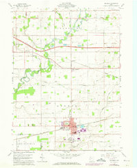
1959 Map of Archbold
USGS Topo · Published 1972About this map
The Penn Central and Norfolk and Western railroads converge at Archbold, anchoring a landscape defined by organized agricultural plots and small family-named landmarks. This 1959 survey, updated with 1971 revisions, details the rural character of Franklin and German townships before significant modern expansion. The Ohio Turnpike cuts a straight path across the northern half of the sheet, contrasting with the meandering curves of the Tiffin River and Bean Creek. Genealogists will find a wealth of local history in the numerous country churches and burial grounds, such as Bethel Ch, Iglesia Ch, Rupp Cem, and James Cem. The map also captures the local recreation and civic life of the era at Ruihley Park and the municipal Reservoir, alongside industry-related features like several Borrow Pits near the turnpike corridor.
Find a feature on this map
41 named features on this map. Tap any name to fly to it.
Don’t see what you’re looking for? This feature index may not catch every label — zoom into the map to look around manually.
Map Details
Editions of this 1959 Archbold Map
2 editions found

Other maps of this area

1907 · Defiance
USGS Topo · 1:62,500

1908 · Napoleon
USGS Topo · 1:62,500

1909 · Defiance
USGS Topo · 1:62,500

1911 · Wauseon
USGS Topo · 1:62,500

1913 · Wauseon
USGS Topo · 1:62,500

1913 · Alvordton
USGS Topo · 1:62,500

1943 · Wauseon
USGS Topo · 1:62,500

1944 · Alvordton
USGS Topo · 1:62,500

1953 · Fort Wayne
USGS Topo · 1:250,000

1956 · Fort Wayne
USGS Topo · 1:250,000