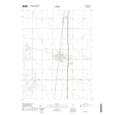
2021 Map of Arcola
USGS Topo · Published 2021About this map
The city of Arcola serves as the central hub of this East Central Illinois landscape, where the flat agricultural prairie of the Grand Prairie region is divided by an orderly grid of section roads. Located primarily within Douglas County, the area is defined by its deep ties to the land and a history of managed drainage, exemplified by the Arcola Drainage Ditch Number 4. To the north, the small settlement of Galton sits along the rail line and highway corridor that bisects the map vertically. Genealogists will find a wealth of data across several burial grounds, including the Arcola Township Cem on the eastern edge of the city and the Campbell Cem to the west. The southern portion of the map crosses into Coles County, where the meandering course of the Kaskaskia River provides a rare break in the geometric regularity of the surrounding farmsteads.
Find a feature on this map
54 named features on this map. Tap any name to fly to it.
Don’t see what you’re looking for? This feature index may not catch every label — zoom into the map to look around manually.
Map Details
Editions of this 2021 Arcola Map
This is the sole edition of this map. No revisions or reprints were ever made.
Other maps of this area

1935 · Arcola
USGS Topo · 1:48,000

1936 · Oakland
USGS Topo · 1:48,000

1940 · Arcola
USGS Topo · 1:62,500

1942 · Oakland
USGS Topo · 1:62,500

1950 · Tuscola
USGS Topo · 1:62,500

1956 · Villa Grove
USGS Topo · 1:62,500

1958 · Decatur
USGS Topo · 1:250,000

1961 · Decatur
USGS Topo · 1:250,000
1975 · Tuscola SW
USGS Topo · 1:24,000
1975 · Tuscola SE
USGS Topo · 1:24,000