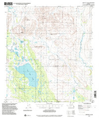
1972 Map of Arctic A-2
USGS Topo · Published 2000About this map
Old John Lake dominates the southwestern quadrant of this Alaskan wilderness, serving as a focal point for a landscape defined by expansive wetlands and isolated peaks. This 1972 survey, published later to include boundaries for the Arctic National Wildlife Refuge, documents a transition between the northern heights of Titus Mountain and the water-heavy lowlands where Vanticlese Creek and Tritt Creek drain toward the interior. The presence of a solitary Cabin near the lake's western shore suggests the minimal human footprint of the era, likely used by trappers or researchers.
Find a feature on this map
17 named features on this map. Tap any name to fly to it.
Don’t see what you’re looking for? This feature index may not catch every label — zoom into the map to look around manually.
Map Details
Editions of this 1972 Arctic A-2 Map
2 editions found
Other maps of this area

1951 · Christian
USGS Topo · 1:250,000

1951 · Arctic
USGS Topo · 1:250,000

1956 · Arctic
USGS Topo · 1:250,000

1956 · Christian
USGS Topo · 1:250,000
1972 · Arctic A-1
USGS Topo · 1:63,360

1972 · Arctic A-3
USGS Topo · 1:63,360
1972 · Christian D-2
USGS Topo · 1:63,360
1972 · Christian D-3
USGS Topo · 1:63,360

1972 · Arctic A-2
USGS Topo · 1:63,360

1983 · Arctic B-2
USGS Topo · 1:63,360