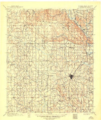
1986 Map of Ardmore
USGS Topo · Published 1990About this map
The Arbuckle Mountains dominate the northeastern reaches of this mid-1980s survey, rising above a landscape defined by its deep connection to the petroleum industry. Vast energy developments such as the Palacine Oil Field, Healdton Oil Field, and the Sholem Alechem Oil Field are clearly delineated, illustrating the heavy industrial footprint across Carter and Stephens counties. The regional hub of Ardmore is situated at the intersection of critical transport lines, including the Atchison Topeka and Santa Fe railroad, which historically facilitated the movement of crude and cattle.
Find a feature on this map
71 named features on this map. Tap any name to fly to it.
Don’t see what you’re looking for? This feature index may not catch every label — zoom into the map to look around manually.
Map Details
Editions of this 1986 Ardmore Map
2 editions found

Historical Maps of Ardmore Through Time
5 maps found