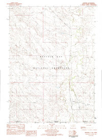
1982 Map of Ardmore
USGS Topo · Published 1982About this map
Ardmore stands as the primary settlement on this borderlands survey, situated along the tracks of the Burlington Northern railroad. The geography is defined by a dense network of intermittent drainages, including Hat Creek, Duck Creek, and Long Branch, which carve through the high plains. A significant portion of the landscape falls within the Buffalo Gap National Grassland, reflecting the transition from private ranching to federal land management in this part of Fall River Co. Topographic landmarks such as Hunter Hill overlook the intersection of the South Dakota and Nebraska state line, where the prairie is etched with numerous family-named branches like Short Branch and North Fork Duck Creek. The arrangement of section lines and isolated homesteads illustrates the remote, rural character of the Great Plains during the early 1980s.
Find a feature on this map
15 named features on this map. Tap any name to fly to it.
Don’t see what you’re looking for? This feature index may not catch every label — zoom into the map to look around manually.
Map Details
Editions of this 1982 Ardmore Map
This is the sole edition of this map. No revisions or reprints were ever made.
Other maps of this area

1902 · Edgemont
USGS Topo · 1:125,000

1950 · Heppner
USGS Topo · 1:24,000

1950 · Rumford
USGS Topo · 1:24,000

1955 · Hot Springs
USGS Topo · 1:250,000

1955 · Alliance
USGS Topo · 1:250,000

1957 · Alliance
USGS Topo · 1:250,000

1958 · Alliance
USGS Topo · 1:250,000

1980 · Montrose
USGS Topo · 1:24,000
1980 · Orella
USGS Topo · 1:24,000
1980 · Story NE
USGS Topo · 1:24,000