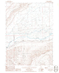
1985 Map of Argenta
USGS Topo · Published 1986About this map
Argenta and its namesake siding sit at the heart of this Nevada landscape, where the Humboldt River carves through a wide valley between the Sheep Creek Range and the Shoshone Range. This mid-1980s document illustrates a high-desert environment defined by mining and ranching, with the Southern Pacific railroad line following the river's path. Numerous mining operations are documented in the southern hills, including the Shelton Mine, Argenta Mine, and several unnamed Prospects, indicating the intensive mineral exploration of the era. The presence of Blue Slough and the Gaging Station near Mosel reflects the critical importance of water management in Boulder Valley. Smaller outposts like Kampos and the T-S Ranch appear alongside the intricate topography of the Argenta Rim, providing a detailed record of the region's sparse but deliberate settlement patterns.
Find a feature on this map
36 named features on this map. Tap any name to fly to it.
Don’t see what you’re looking for? This feature index may not catch every label — zoom into the map to look around manually.
Map Details
Editions of this 1985 Argenta Map
This is the sole edition of this map. No revisions or reprints were ever made.
Other maps of this area

1955 · Winnemucca
USGS Topo · 1:250,000

1957 · Dunphy
USGS Topo · 1:62,500

1957 · Battle Mountain
USGS Topo · 1:62,500

1958 · Winnemucca
USGS Topo · 1:250,000

1962 · Winnemucca
USGS Topo · 1:250,000

1965 · Sheep Creek Range SW
USGS Topo · 1:24,000

1965 · Sheep Creek Range SE
USGS Topo · 1:24,000
1965 · Izzenhood Spring
USGS Topo · 1:24,000
1985 · The Geysers
USGS Topo · 1:24,000
1985 · Stony Point
USGS Topo · 1:24,000