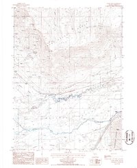
1985 Map of Stony Point
USGS Topo · Published 1986About this map
Mining and transportation networks converge along the Humboldt River in this mid-1980s topographical study. The northern landscape is dominated by the Sheep Creek Range, marked by numerous prospects and industrial sites like the Snowstorm Mine and associated Tailings Ponds. The rugged topography of the mountains gives way to the broad Boulder Valley floor, where the river winds past McIntyre Slough and multiple Hot Spring sites.
Find a feature on this map
32 named features on this map. Tap any name to fly to it.
Don’t see what you’re looking for? This feature index may not catch every label — zoom into the map to look around manually.
Map Details
Editions of this 1985 Stony Point Map
This is the sole edition of this map. No revisions or reprints were ever made.
Other maps of this area

1955 · Winnemucca
USGS Topo · 1:250,000

1957 · Dunphy
USGS Topo · 1:62,500

1957 · Battle Mountain
USGS Topo · 1:62,500

1958 · Winnemucca
USGS Topo · 1:250,000

1962 · Winnemucca
USGS Topo · 1:250,000

1965 · Russells
USGS Topo · 1:24,000

1965 · Sheep Creek Range SW
USGS Topo · 1:24,000
1965 · Izzenhood Spring
USGS Topo · 1:24,000
1985 · Battle Mountain
USGS Topo · 1:24,000
1985 · Mule Canyon
USGS Topo · 1:24,000