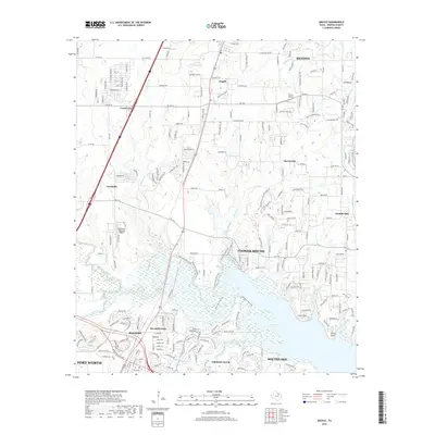
2019 Map of Argyle
USGS Topo · Published 2019About this map
Grapevine Lake and its northern inlets form the geographic anchor of this landscape on the northern edge of the Dallas-Fort Worth metroplex. In this era of rapid suburban expansion, the map details the established and growing communities of Roanoke, Trophy Club, and Flower Mound. The shoreline is characterized by distinct terrain features like Bolo Point and Rocky Point, while the northern reaches transitions into the residential and equestrian-influenced layouts of Argyle and Bartonville. Aviation and infrastructure are prominent, with Northwest Regional Airport serving the area near Northlake. The presence of the Knob Hills MTB Trail winding through the hills above Denton Creek highlights the balance of recreational space amidst the increasing density of residential developments and rural-to-urban transit corridors.
Find a feature on this map
34 named features on this map. Tap any name to fly to it.
Don’t see what you’re looking for? This feature index may not catch every label — zoom into the map to look around manually.
Map Details
Editions of this 2019 Argyle Map
This is the sole edition of this map. No revisions or reprints were ever made.
Other maps of this area

1894 · Fort Worth
USGS Topo · 1:125,000

1931 · Grapevine
USGS Topo · 1:62,500

1954 · Dallas
USGS Topo · 1:250,000

1954 · Sherman
USGS Topo · 1:250,000

1955 · Keller
USGS Topo · 1:24,000

1955 · Haltom City
USGS Topo · 1:62,500

1958 · Dallas
USGS Topo · 1:250,000

1958 · Sherman
USGS Topo · 1:250,000
1959 · Grapevine
USGS Topo · 1:24,000
1959 · Colleyville
USGS Topo · 1:24,000