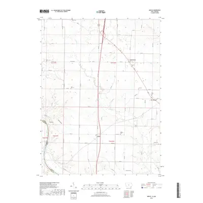
2018 Map of Argyle
USGS Topo · Published 2018About this map
Argyle, Charleston, and New Boston anchor this landscape along the southeastern corner of Lee County, Iowa, just north of the Missouri border. The area is defined by the winding course of Sugar Cr, which carves through the terrain alongside numerous tributaries like Birch Cr and Goose Cr. This rural expanse is notable for its high density of local burial grounds, including the Argyle Memorial Cem, Ambrosia Cem, and Saint Marys Cem, which serve as vital markers for genealogical research in these small communities. In the southwest, the terrain drops toward the Des Moines River, passing landmarks such as Bryan Hill and the evocatively named Ghost Hollow. The map reveals a persistent pattern of rural life where the section-line road network, including Charleston Rd and Croton Rd, adapts to the rolling drainage basins of the Mississippi River watershed.
Find a feature on this map
65 named features on this map. Tap any name to fly to it.
Don’t see what you’re looking for? This feature index may not catch every label — zoom into the map to look around manually.
Map Details
Editions of this 2018 Argyle Map
This is the sole edition of this map. No revisions or reprints were ever made.
Other maps of this area

1903 · Kahoka
USGS Topo · 1:125,000

1936 · Keokuk
USGS Topo · 1:62,500

1936 · Fort Madison
USGS Topo · 1:62,500

1949 · Wayland
USGS Topo · 1:24,000

1949 · Kahoka
USGS Topo · 1:24,000

1950 · Kahoka
USGS Topo · 1:24,000

1950 · Wayland
USGS Topo · 1:24,000

1950 · Keokuk
USGS Topo · 1:62,500

1958 · Burlington
USGS Topo · 1:250,000

1961 · Burlington
USGS Topo · 1:250,000