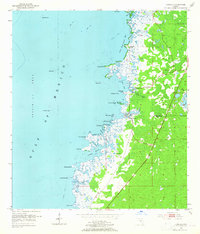
1954 Map of Aripeka
USGS Topo · Published 1965About this map
Aripeka serves as the primary coastal settlement on this mid-century survey, situated along the line dividing Hernando and Pasco Counties. The landscape is dominated by a complex network of wetlands and tidal inlets where Indian Creek and Rocky Creek meet the Gulf of Mexico. This map reveals a coastline defined by intricate island chains and local landmarks such as Palm Island, Hammock Island, and the curiously named Devils Rock Yard. Inland, the presence of Gravel Pits and the early alignment of Florida 595 point to the local infrastructure and resource extraction of the 1950s. The hydrography is particularly detailed, showing navigable passages like The Cutoff and the secluded waters of Fillman Bayou, providing an intimate look at the Gulf Coast's natural geography before late-20th-century development altered many of these Florida shorelines.
Find a feature on this map
39 named features on this map. Tap any name to fly to it.
Don’t see what you’re looking for? This feature index may not catch every label — zoom into the map to look around manually.
Map Details
Editions of this 1954 Aripeka Map
4 editions found
Other maps of this area

1954 · Port Richey
USGS Topo · 1:24,000

1954 · Fivay
USGS Topo · 1:24,000

1954 · Aripeka
USGS Topo · 1:24,000

1954 · Bayport
USGS Topo · 1:24,000

1954 · Weekiwachee Springs
USGS Topo · 1:24,000

1954 · Port Richey NE
USGS Topo · 1:24,000

1955 · Plant City
USGS Topo · 1:250,000

1958 · Plant City
USGS Topo · 1:250,000

1959 · Plant City
USGS Topo · 1:250,000

1964 · Plant City
USGS Topo · 1:250,000