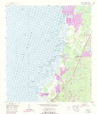
1954 Map of Aripeka
USGS Topo · Published 1988About this map
Aripeka sits at the junction of the Hernando Co Pasco Co line, serving as a focal point for this coastal Florida landscape during the mid-20th century. The intricate shoreline is defined by a series of points and keys, including Gun Point and Indian Key, which buffer the mainland from the Gulf of Mexico. Inland, the map reveals a transition from coastal wetlands and bayous like Fillman Bayou to developing residential areas and recreational features such as a Golf Course. The 1988 photorevision (noted in purple) highlights significant suburban expansion around Hunters Lake and the northern reaches near Rocky Creek, contrasting with the more natural terrain of the 1954 base survey. Notable local landmarks like the Gravel Pit and the unusually named Devils Rock Yard provide specific points of interest for those tracing the industrial and geographic evolution of the Gulf Coast.
Find a feature on this map
42 named features on this map. Tap any name to fly to it.
Don’t see what you’re looking for? This feature index may not catch every label — zoom into the map to look around manually.
Map Details
Editions of this 1954 Aripeka Map
4 editions found
Other maps of this area

1954 · Port Richey
USGS Topo · 1:24,000

1954 · Fivay
USGS Topo · 1:24,000

1954 · Aripeka
USGS Topo · 1:24,000

1954 · Bayport
USGS Topo · 1:24,000

1954 · Weekiwachee Springs
USGS Topo · 1:24,000

1954 · Port Richey NE
USGS Topo · 1:24,000

1955 · Plant City
USGS Topo · 1:250,000

1958 · Plant City
USGS Topo · 1:250,000

1959 · Plant City
USGS Topo · 1:250,000

1964 · Plant City
USGS Topo · 1:250,000