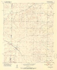
1951 Map of Arkinda
USGS Topo · Published 1952About this map
The St Louis San Francisco railroad cuts a diagonal path through this 1951 survey, anchoring the settlement of Arkinda near the state line. This borderland between Oklahoma and Arkansas is defined by its small community centers and an extensive network of rural schools and churches, such as Saints Rest Ch and King Rider Sch. The landscape is characterized by its numerous drainage systems, including the various branches of Caney Creek and the southern flow of Hurricane Creek. Genealogists will find a high density of family and community burial grounds, from the Strawn Cem in the north to the Eastport Cem and New Home Cem further south. The presence of several Gravel Pits suggests localized resource extraction along the ridges, while established places like Jewell and Cross Roads mark the intersection of early post-war rural life and commerce.
Find a feature on this map
36 named features on this map. Tap any name to fly to it.
Don’t see what you’re looking for? This feature index may not catch every label — zoom into the map to look around manually.
Map Details
Editions of this 1951 Arkinda Map
4 editions found
Other maps of this area

1950 · Tom
USGS Topo · 1:24,000

1950 · Winthrop
USGS Topo · 1:24,000

1950 · Goodwater
USGS Topo · 1:24,000

1950 · Bokhoma
USGS Topo · 1:24,000

1951 · Winthrop
USGS Topo · 1:24,000

1951 · Tom
USGS Topo · 1:24,000

1951 · Bokhoma
USGS Topo · 1:24,000

1951 · Goodwater
USGS Topo · 1:24,000

1951 · Arden
USGS Topo · 1:24,000

1951 · Arkinda
USGS Topo · 1:24,000