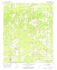
1951 Map of Arkinda
USGS Topo · Published 1976About this map
The Oklahoma Arkansas state line bisects this landscape, where the St Louis San Francisco railroad cuts a diagonal path through the settlement of Arkinda. This mid-century survey documents a rural community structure defined by its scattered schools and family cemeteries. To the north, Jewell and the Oak Grove Sch sit near the headwaters of Caney Creek, while the southern reaches near Jefferson township include the Miller Sch and Climax Sch.
Find a feature on this map
35 named features on this map. Tap any name to fly to it.
Don’t see what you’re looking for? This feature index may not catch every label — zoom into the map to look around manually.
Map Details
Editions of this 1951 Arkinda Map
4 editions found
Other maps of this area

1950 · Tom
USGS Topo · 1:24,000

1950 · Winthrop
USGS Topo · 1:24,000

1950 · Goodwater
USGS Topo · 1:24,000

1950 · Bokhoma
USGS Topo · 1:24,000

1951 · Winthrop
USGS Topo · 1:24,000

1951 · Tom
USGS Topo · 1:24,000

1951 · Bokhoma
USGS Topo · 1:24,000

1951 · Goodwater
USGS Topo · 1:24,000

1951 · Arden
USGS Topo · 1:24,000

1951 · Arkinda
USGS Topo · 1:24,000