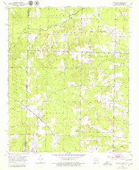
1951 Map of Arkinda
USGS Topo · Published 1979About this map
The St Louis and San Francisco railroad cuts diagonally through the landscape of the Arkansas-Oklahoma border, anchoring the small settlement of Arkinda. This 1951 survey reveals a rural landscape defined by township boundaries like Caney, Jewell, and Little River, where local life centered around small country schools and community burial grounds. Educational centers such as Oak Grove Sch and Miller Sch served the surrounding farmsteads, while the terrain is marked by numerous family and community cemeteries, including Strawn Cem, Eastport Cem, and New Home Cem. The western edge of the map transitions into the Ouachita National Forest, where the topography becomes increasingly complex around the headwaters of Caney Creek. Several gravel Pits suggest local extractive activity, highlighting the transition from the timbered heights of the forest to the agricultural plains bisected by the railway.
Find a feature on this map
36 named features on this map. Tap any name to fly to it.
Don’t see what you’re looking for? This feature index may not catch every label — zoom into the map to look around manually.
Map Details
Editions of this 1951 Arkinda Map
4 editions found
Other maps of this area

1950 · Tom
USGS Topo · 1:24,000

1950 · Winthrop
USGS Topo · 1:24,000

1950 · Goodwater
USGS Topo · 1:24,000

1950 · Bokhoma
USGS Topo · 1:24,000

1951 · Winthrop
USGS Topo · 1:24,000

1951 · Tom
USGS Topo · 1:24,000

1951 · Bokhoma
USGS Topo · 1:24,000

1951 · Goodwater
USGS Topo · 1:24,000

1951 · Arden
USGS Topo · 1:24,000

1951 · Arkinda
USGS Topo · 1:24,000