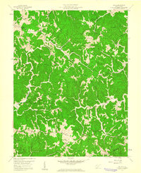
1958 Map of Arlee
USGS Topo · Published 1960About this map
The Chief Cornstalk State Hunting Ground dominates the northern and central portions of this 1958 survey, illustrating the conservation and recreational land use patterns in rural Mason County during the mid-century. The settlement of Arlee sits along the northern edge, surrounded by a dense network of family-named landmarks and rural institutions. The topography is defined by prominent ridges such as Hambrick Ridge, Sevenmile Ridge, and Loggerhead Ridge, which dictate the placement of early roads and small communities.
Find a feature on this map
42 named features on this map. Tap any name to fly to it.
Don’t see what you’re looking for? This feature index may not catch every label — zoom into the map to look around manually.
Map Details
Editions of this 1958 Arlee Map
Other maps of this area

1906 · Glenwood
USGS Topo · 1:62,500

1906 · Winfield
USGS Topo · 1:62,500

1908 · Glenwood
USGS Topo · 1:62,500

1908 · Winfield
USGS Topo · 1:62,500

1908 · Ravenswood
USGS Topo · 1:62,500

1908 · Point Pleasant
USGS Topo · 1:62,500

1926 · Ravenswood
USGS Topo · 1:62,500

1926 · Point Pleasant
USGS Topo · 1:62,500

1928 · Ravenswood
USGS Topo · 1:62,500

1929 · Point Pleasant
USGS Topo · 1:62,500