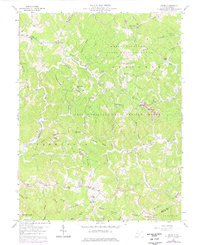
1958 Map of Arlee
USGS Topo · Published 1976About this map
The settlement of Arlee sits at a crossroads in rural Mason County, where the landscape is defined by the steep divides of SEVENMILE Ridge, Loggerhead Ridge, and Hambrick Ridge. This 1958 survey, updated with 1975 photorevisions, shows a community deeply rooted in its terrain, with narrow hollows like Opossum Hollow and Barn Hollow providing the primary conduits for local travel. The presence of numerous small congregations, including Zion Ch, Pine Grove Ch, and Mt Carmel Ch, alongside educational landmarks like Woods Sch and Buckle Sch, illustrates the decentralized social fabric of the era. A significant portion of the land is dedicated to the Chief Cornstalk State Hunting Ground, which includes the Chief Cornstalk Headquarters. The map captures the intricate drainage system of the West Virginia backcountry, tracing the winding paths of Sixteenmile Creek and its many forks that dictated the placement of family cemeteries and homesteads.
Find a feature on this map
75 named features on this map. Tap any name to fly to it.
Don’t see what you’re looking for? This feature index may not catch every label — zoom into the map to look around manually.
Map Details
Editions of this 1958 Arlee Map
Other maps of this area

1906 · Glenwood
USGS Topo · 1:62,500

1906 · Winfield
USGS Topo · 1:62,500

1908 · Glenwood
USGS Topo · 1:62,500

1908 · Winfield
USGS Topo · 1:62,500

1908 · Ravenswood
USGS Topo · 1:62,500

1908 · Point Pleasant
USGS Topo · 1:62,500

1926 · Ravenswood
USGS Topo · 1:62,500

1926 · Point Pleasant
USGS Topo · 1:62,500

1928 · Ravenswood
USGS Topo · 1:62,500

1929 · Point Pleasant
USGS Topo · 1:62,500