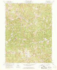
1958 Map of Arlee
USGS Topo · Published 1969About this map
Chief Cornstalk State Hunting Ground dominates the central and northern reaches of this map, illustrating the state's conversion of these wooded ridges into protected recreational space. The landscape is defined by its extreme topography, where narrow, winding ridges like Loggerhead Ridge and Sevenmile Ridge separate deep-cut hollows and small watercourses. The settlement of Arlee sits at a high elevation junction, while the surrounding hills are dotted with rural landmarks that speak to the area's social history. Genealogists will find a wealth of specific family and community sites, including numerous country churches such as Potts Chapel and Siloam Ch, alongside small cemeteries like Barrs Chapel Cem and Williamson Cem. The presence of Woods Sch and Buckle Sch highlights the scattered nature of rural education in Mason and Putnam Counties before the era of widespread school consolidation.
Find a feature on this map
68 named features on this map. Tap any name to fly to it.
Don’t see what you’re looking for? This feature index may not catch every label — zoom into the map to look around manually.
Map Details
Editions of this 1958 Arlee Map
Other maps of this area

1906 · Glenwood
USGS Topo · 1:62,500

1906 · Winfield
USGS Topo · 1:62,500

1908 · Glenwood
USGS Topo · 1:62,500

1908 · Winfield
USGS Topo · 1:62,500

1908 · Ravenswood
USGS Topo · 1:62,500

1908 · Point Pleasant
USGS Topo · 1:62,500

1926 · Ravenswood
USGS Topo · 1:62,500

1926 · Point Pleasant
USGS Topo · 1:62,500

1928 · Ravenswood
USGS Topo · 1:62,500

1929 · Point Pleasant
USGS Topo · 1:62,500