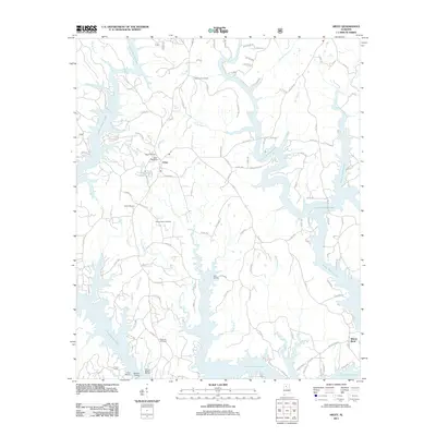
2011 Map of Arley
USGS Topo · Published 2011About this map
The town of Arley serves as the central hub in this survey of Winston County, Alabama, where the landscape is defined by the expansive, multi-fingered reaches of Lewis Smith Lake. The intricate shoreline created by the impoundment of water into valleys like Dismal Creek and Cutoff Branch has transformed former stream beds into deep-water inlets, significantly altering the local geography. This 2011 record documents the developed recreational and residential character of the lakefront at Wilson Bend and Arley Landing, supported by maritime infrastructure like Hueys Marina and the prominent Duncan Bridge.
Find a feature on this map
107 named features on this map. Tap any name to fly to it.
Don’t see what you’re looking for? This feature index may not catch every label — zoom into the map to look around manually.
Map Details
Editions of this 2011 Arley Map
This is the sole edition of this map. No revisions or reprints were ever made.
Other maps of this area

1893 · Jasper
USGS Topo · 1:125,000

1949 · Cold Springs
USGS Topo · 1:24,000

1949 · Manchester
USGS Topo · 1:24,000

1949 · Sunlight
USGS Topo · 1:24,000

1950 · Manchester
USGS Topo · 1:24,000

1951 · Cold Springs
USGS Topo · 1:24,000
1951 · Sunlight
USGS Topo · 1:24,000

1953 · Birmingham
USGS Topo · 1:250,000

1956 · Birmingham
USGS Topo · 1:250,000

1956 · Gadsden
USGS Topo · 1:250,000