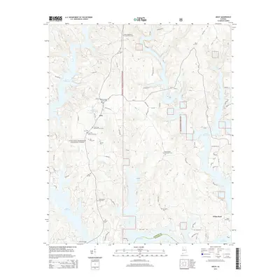
2014 Map of Arley
USGS Topo · Published 2014About this map
Lewis Smith Lake dominates this portion of the Cumberland Plateau, its branching fingers reaching into the deep drainages of Sipsey Br and Bear Br. The settlement of Arley serves as a central hub for the surrounding rural community, situated just west of the William B. Bankhead National Forest boundary. This area is characterized by a high density of country churches and family burial grounds, reflecting the deep-rooted genealogical history of Winston County. Many landmarks carry family names, such as Trussell Cem, John Brown Cem, and the Delma Baird Cem near Wilson Bend. The map documents the intricate network of local county roads and residential developments that follow the winding shoreline, including areas like Pine Point Rd and Hosanna Hwy. Farther south, the Winston and Walker county line crosses the lake near the Duncan Bridge.
Find a feature on this map
98 named features on this map. Tap any name to fly to it.
Don’t see what you’re looking for? This feature index may not catch every label — zoom into the map to look around manually.
Map Details
Editions of this 2014 Arley Map
This is the sole edition of this map. No revisions or reprints were ever made.
Other maps of this area

1893 · Jasper
USGS Topo · 1:125,000

1949 · Cold Springs
USGS Topo · 1:24,000

1949 · Manchester
USGS Topo · 1:24,000

1949 · Sunlight
USGS Topo · 1:24,000

1950 · Manchester
USGS Topo · 1:24,000

1951 · Cold Springs
USGS Topo · 1:24,000
1951 · Sunlight
USGS Topo · 1:24,000

1953 · Birmingham
USGS Topo · 1:250,000

1956 · Birmingham
USGS Topo · 1:250,000

1956 · Gadsden
USGS Topo · 1:250,000