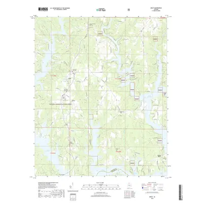
2018 Map of Arley
USGS Topo · Published 2018About this map
The town of Arley and the surrounding woodlands of the William B. Bankhead National Forest define this corner of Winston County. The landscape is deeply carved by the serpentine fingers of Lewis Smith Lake, which creates a complex network of peninsulas and coves fed by waterways like Dismal Cr and Cutoff Br. This modern survey illustrates how local transportation and settlement patterns are dictated by the water, with roads like Wilson Bend Rd and Hosanna Hwy following the high ridges between lake arms. For genealogists, the map is remarkably dense with burial sites and rural congregations, ranging from the central Meek Baptist Church Cem to the outlying Old Bethel Cem and Taylor-Hill Cem. These landmarks, along with family-named locations like Wilson Bend and Bluff Pt, preserve the social geography of the region as it transitions into a recreational and residential lakeside landscape.
Find a feature on this map
78 named features on this map. Tap any name to fly to it.
Don’t see what you’re looking for? This feature index may not catch every label — zoom into the map to look around manually.
Map Details
Editions of this 2018 Arley Map
This is the sole edition of this map. No revisions or reprints were ever made.
Other maps of this area

1893 · Jasper
USGS Topo · 1:125,000

1949 · Cold Springs
USGS Topo · 1:24,000

1949 · Manchester
USGS Topo · 1:24,000

1949 · Sunlight
USGS Topo · 1:24,000

1950 · Manchester
USGS Topo · 1:24,000

1951 · Cold Springs
USGS Topo · 1:24,000
1951 · Sunlight
USGS Topo · 1:24,000

1953 · Birmingham
USGS Topo · 1:250,000

1956 · Birmingham
USGS Topo · 1:250,000

1956 · Gadsden
USGS Topo · 1:250,000