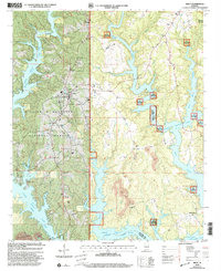
2000 Map of Arley
USGS Topo · Published 2003About this map
Arley is situated along the western ridges above the sprawling fingers of Lewis Smith Lake. This terrain, dominated by the William B. Bankhead National Forest, showcases a complex landscape where forested uplands meet the intricate shoreline of the Sipsey Fork. The map records a concentration of civic and spiritual life near the town center, including the Meek High School, Meek Church, and Arley Church. Outside the main settlement, rural life is marked by several long-standing landmarks such as Robertson Chapel and Bethel Church. To the south and east, the industrial impact on the landscape is visible through several marked Strip Mines near Piney Ridge. The irregular coastline of the lake, including prominent features like Wilson Bend, reflects the dramatic topography created by the damming of these river forks, while high points like Meek Lookout provide orientation over the timbered hills.
Find a feature on this map
34 named features on this map. Tap any name to fly to it.
Don’t see what you’re looking for? This feature index may not catch every label — zoom into the map to look around manually.
Map Details
Editions of this 2000 Arley Map
This is the sole edition of this map. No revisions or reprints were ever made.
Other maps of this area

1893 · Jasper
USGS Topo · 1:125,000

1949 · Cold Springs
USGS Topo · 1:24,000

1949 · Manchester
USGS Topo · 1:24,000

1949 · Sunlight
USGS Topo · 1:24,000

1950 · Manchester
USGS Topo · 1:24,000

1951 · Cold Springs
USGS Topo · 1:24,000
1951 · Sunlight
USGS Topo · 1:24,000

1953 · Birmingham
USGS Topo · 1:250,000

1956 · Birmingham
USGS Topo · 1:250,000

1956 · Gadsden
USGS Topo · 1:250,000