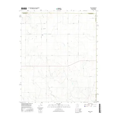
2016 Map of Arlie
USGS Topo · Published 2016About this map
Arlie sits within a landscape defined by intermittent watercourses and the grid of rural Texas county roads just south of the Collingsworth and Childress County line. The settlement is anchored by the Arlie Cem, a vital point of reference for genealogists tracing pioneer families in this corner of the Panhandle. The terrain is drained by several branches of the Red River watershed, including the W Fork Sandy Cr, Settlers Cr, and Soldier's Cr. These seasonal creeks cut across the ranching country, where large-scale land management is indicated by thoroughfares such as Ranch Rd 1034 and Ranch Rd 1642. The mapping reflects a modern era of land use where the original cattle trails have been replaced by a systematic road network, though the underlying topography remains the primary influence on habitation patterns.
Find a feature on this map
24 named features on this map. Tap any name to fly to it.
Don’t see what you’re looking for? This feature index may not catch every label — zoom into the map to look around manually.
Map Details
Editions of this 2016 Arlie Map
This is the sole edition of this map. No revisions or reprints were ever made.
Other maps of this area

1954 · Plainview
USGS Topo · 1:250,000

1955 · Lawton
USGS Topo · 1:250,000

1958 · Plainview
USGS Topo · 1:250,000

1960 · Loco
USGS Topo · 1:62,500

1961 · Hollis
USGS Topo · 1:62,500

1964 · Wellington
USGS Topo · 1:24,000

1964 · Dodson
USGS Topo · 1:24,000
1971 · Mc Knight
USGS Topo · 1:24,000
1975 · Hollis NW
USGS Topo · 1:24,000
1984 · Arlie
USGS Topo · 1:24,000