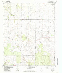
1984 Map of Arlie
USGS Topo · Published 1985About this map
Arlie sits as the central point of interest in this 1980s landscape, positioned near the boundary where Collingsworth and Childress counties meet. The map documents a sparsely settled agricultural and ranching region of the Texas Panhandle, evidenced by the scattered network of wells and a solitary Grain Bin located south of the main settlement. The topography is defined by the drainage systems of West Fork Sandy Creek and Settlers Creek, which carve through the terrain as they move toward the Oklahoma border.
Find a feature on this map
11 named features on this map. Tap any name to fly to it.
Don’t see what you’re looking for? This feature index may not catch every label — zoom into the map to look around manually.
Map Details
Editions of this 1984 Arlie Map
This is the sole edition of this map. No revisions or reprints were ever made.
Other maps of this area

1954 · Plainview
USGS Topo · 1:250,000

1955 · Lawton
USGS Topo · 1:250,000

1958 · Plainview
USGS Topo · 1:250,000

1960 · Loco
USGS Topo · 1:62,500

1961 · Hollis
USGS Topo · 1:62,500

1964 · Wellington
USGS Topo · 1:24,000

1964 · Dodson
USGS Topo · 1:24,000
1971 · Mc Knight
USGS Topo · 1:24,000
1975 · Hollis NW
USGS Topo · 1:24,000
1984 · Loco
USGS Topo · 1:24,000