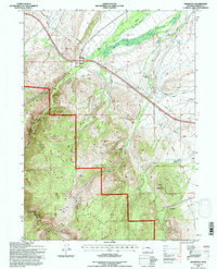
1992 Map of Arlington
USGS Topo · Published 1996About this map
Arlington sits at the northern edge of the Medicine Bow National Forest in Carbon County, representing a landscape where historic transit routes and high-altitude ranching converge. The map documents the legendary Overland Trail as it skirts the foothills of the Laramie Mountains, crossing watercourses like Rock Creek, Foote Creek, and Onemile Creek. Ranching legacy is prominent throughout the terrain, with family and named operations such as Bengough Ranch, Old Fisher Ranch, and Raffer Six Ranch scattered across the drainages. Elevations rise sharply toward Rock Mountain, Deer Mountain, and Cooper Hill, defining a region shaped by both its natural ruggedness and the infrastructure of the late 20th century, including a prominent Pipeline and Aqueduct that traverse the high plains.
Find a feature on this map
25 named features on this map. Tap any name to fly to it.
Don’t see what you’re looking for? This feature index may not catch every label — zoom into the map to look around manually.
Map Details
Editions of this 1992 Arlington Map
This is the sole edition of this map. No revisions or reprints were ever made.
Other maps of this area

1906 · Medicine Bow
USGS Topo · 1:125,000

1908 · Medicine Bow
USGS Topo · 1:125,000

1954 · Rawlins
USGS Topo · 1:250,000

1958 · Rawlins
USGS Topo · 1:250,000

1958 · White Rock Canyon
USGS Topo · 1:24,000

1958 · Bengough Hill
USGS Topo · 1:24,000

1958 · Arlington
USGS Topo · 1:24,000

1958 · Mc Fadden
USGS Topo · 1:24,000
1958 · Pierce Reservoir
USGS Topo · 1:24,000

1958 · T L Ranch
USGS Topo · 1:24,000