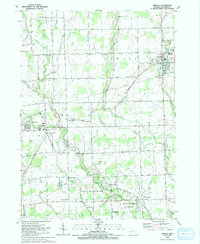
1991 Map of Armada
USGS Topo · Published 1991About this map
The North Branch Clinton River and its complex network of agricultural drainage, including Apel Drain and Wilson Drain, define the landscape of northern Macomb County in this early 1990s study. The village of Armada sits at the crossing of Armada Ridge Road, serving as a hub for the surrounding township. To the southwest, the village of Romeo borders the Romeo Airport, while the sprawling Wolcott Mill Metropark preserves a significant corridor along the main Clinton River. This map captures the transition between small-town Michigan life and the recreational development represented by the park and its historic mill site.
Find a feature on this map
66 named features on this map. Tap any name to fly to it.
Don’t see what you’re looking for? This feature index may not catch every label — zoom into the map to look around manually.
Map Details
Editions of this 1991 Armada Map
This is the sole edition of this map. No revisions or reprints were ever made.
Other maps of this area

1908 · Rochester
USGS Topo · 1:62,500

1912 · Mt Clemens
USGS Topo · 1:62,500

1914 · Armada
USGS Topo · 1:62,500

1928 · Armada
USGS Topo · 1:62,500

1929 · Mt Clemens
USGS Topo · 1:62,500

1936 · New Haven
USGS Topo · 1:31,680

1936 · Washington
USGS Topo · 1:31,680

1936 · Waldenburg
USGS Topo · 1:31,680

1943 · Romeo
USGS Topo · 1:24,000

1944 · Memphis
USGS Topo · 1:24,000