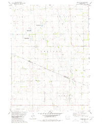
1979 Map of Armour SW
USGS Topo · Published 1980About this map
The Yankton Indian Reservation Boundary cuts diagonally across this landscape, dividing the agricultural townships of Chester and Moore. In the late 1970s, this portion of Douglas and Charles Mix counties was defined by a section-line grid of roads and scattered rural infrastructure. Evidence of former transportation networks remains visible through the Old Railroad Grade running north-south along the eastern edge. Local history is anchored by the German Reform Cem in Moore and School No 33 further east. The terrain is marked by significant conservation efforts, with multiple tracts designated as a National Waterfowl Production Area, reflecting the region's importance for prairie pothole habitat along Andes Creek.
Find a feature on this map
17 named features on this map. Tap any name to fly to it.
Don’t see what you’re looking for? This feature index may not catch every label — zoom into the map to look around manually.
Map Details
Editions of this 1979 Armour SW Map
This is the sole edition of this map. No revisions or reprints were ever made.
Other maps of this area

1955 · Mitchell
USGS Topo · 1:250,000

1959 · Mitchell
USGS Topo · 1:250,000

1964 · Wagner NE
USGS Topo · 1:24,000

1964 · Ravinia
USGS Topo · 1:24,000

1964 · Lake Andes
USGS Topo · 1:24,000
1977 · Wagner NE
USGS Topo · 1:24,000
1977 · Lake Andes
USGS Topo · 1:24,000

1979 · Geddes SE
USGS Topo · 1:24,000

1979 · New Holland
USGS Topo · 1:24,000
1979 · Armour
USGS Topo · 1:24,000