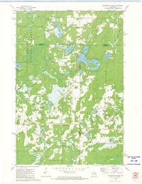
1972 Map of Armstrong Creek
USGS Topo · Published 1974About this map
Armstrong Creek and its surrounding woods in the northern reaches of the Nicolet National Forest reflect a landscape defined by timber, water, and the remnants of early twentieth-century logging. The township of Armstrong Creek serves as a small hub, situated near the intersection of the Soo Line and multiple stretches of Old Railroad Grade that once hauled timber through the dense pine and hardwood stands. The terrain is pocketed with numerous glacial basins including Hilbert Lake, Forest Lake, and the remote Mud Lake, while the Popple River and Armstrong Creek drain the watershed through the heart of the forest.
Find a feature on this map
32 named features on this map. Tap any name to fly to it.
Don’t see what you’re looking for? This feature index may not catch every label — zoom into the map to look around manually.
Map Details
Editions of this 1972 Armstrong Creek Map
2 editions found
Other maps of this area

1939 · Goodman
USGS Topo · 1:48,000

1939 · Laona
USGS Topo · 1:48,000

1939 · Long Lake
USGS Topo · 1:48,000

1941 · Florence
USGS Topo · 1:48,000

1946 · Laona
USGS Topo · 1:48,000

1946 · Goodman
USGS Topo · 1:48,000

1948 · Long Lake
USGS Topo · 1:48,000

1954 · Iron Mountain
USGS Topo · 1:250,000

1959 · Iron Mountain
USGS Topo · 1:250,000
1962 · Florence SW
USGS Topo · 1:24,000