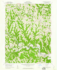
1960 Map of Armstrongs Mills
USGS Topo · Published 1961About this map
Captina Creek meanders through the heart of this landscape, anchoring the village of Armstrongs Mills and the nearby settlement of Alledonia. The 1960 topography reveals a rural economy in transition, where traditional family farms and small crossroad communities like Centerville and Jacobsburg coexist with emerging energy infrastructure. Numerous oil and gas wells are scattered across the townships of Smith, Mead, and Washington, while a Strip Mine and Tipple near the Pennsylvania rail line in the southeast corner signal the industrial presence of coal.
Find a feature on this map
64 named features on this map. Tap any name to fly to it.
Don’t see what you’re looking for? This feature index may not catch every label — zoom into the map to look around manually.
Map Details
Editions of this 1960 Armstrongs Mills Map
2 editions found
Other maps of this area

1903 · Flushing
USGS Topo · 1:62,500

1905 · Clarington
USGS Topo · 1:62,500

1905 · St. Clairsville
USGS Topo · 1:62,500

1905 · Woodsfield
USGS Topo · 1:62,500

1905 · Flushing
USGS Topo · 1:62,500

1935 · Clarington
USGS Topo · 1:62,500

1940 · Clarington
USGS Topo · 1:62,500

1949 · Clarksburg
USGS Topo · 1:250,000

1951 · Canton
USGS Topo · 1:250,000

1953 · Canton
USGS Topo · 1:250,000